Overview of Info in the Karoo
See Google Drive folder for some of the publications mentioned below:
https://drive.google.com/open?id=0B9In9AOnWyDRY0ZzZ0dKMzBzQUk
Shale Gas Reports: (Google Drive > 13 Economic ... > Reports on Shale Gas)
1. ASSAf - SA's Techinical Readiness to Support the Shale Gas Industry (2017)
- http://research.assaf.org.za/handle/20.500.11911/14
2. Govt, CSIR and CGS - Shale Gas Development in the Central Karoo: A Scientific Assessment of the Opportunities and Risks (2017)
- https://seasgd.csir.co.za/scientific-assessment-chapters/
- YouTube video (Bob Scholes presentation): https://www.youtube.com/watch?v=-GKp2_wcx4M
3. Decker (2012) - Investigation of hydraulic fracturing in the Karoo Basin of SA [DMR, CGS and PASA]
4. deWit (2011) - The great shale debate in the Karoo [Aeon]
5. Cole (2011) - Shale gas targets in the Ecca Group of the Main Karoo Basin, SA (SAGA abstract) [CGS]
6. Cole et al. (2011) - Report on the geology of shales with a gas potential in the main Karoo Basin of SA [CGS]
Geophysics and Geology:
1. Africa Earth Observatory Network (AEON), NNMU (Figure 1)
See report: AEON Shale Gas Report 15Nov 2018
(Google Drive > 13 Economic ... > Reports on Shale Gas)
2. Professor Oswald Gwavava and Professor Ken Liv and their research group at the University of Fort
Hare have been working with existing geophysical data in the Karoo Basin in the
Eastern Cape, as well as collecting new geological and geophysical data in this
area (e.g., Baiyegunhi et al,
2019)
3. Professor
Emese Bordy at University of Cape Town (UCT) who has a significant research
group of students working on the Karoo and Cape Supergroup (e.g., Bordy and
Smithard, 2015);
4. Dr Lauren Hoyer at University of KwaZulu Natal who is working
on the dolerite sills and dykes (e.g., Hoyer and Watkeys, 2016), as well as
associated hydrothermal vents,
5. PhD student André
Coetzee from Stellenbosch
University who has been mapping sills and dykes in the Karoo (Google Drive > 15 Dolerites > Coetzee)
6. Researchers at the University of the Western Cape are also involved in shale
gas related projects under Dr Abdi Siad.
Soekor borehole data: (Google Drive > 02 Straigraphy... > Boreholes in the Karoo)
1. Rowsell and de Swardt (1976) (Some of red triangles in Figure 2) [Soekor]
2. Scheiber-Enslin et al. (2014) [Wits and CGS]
Newer boreholes: (Google Drive > 02 Straigraphy... > Boreholes in the Karoo)
1. Doug Cole's database (includes CGS and industry boreholes) (see Table 2 in Scheiber-Enslin et al. (2015) for summary) [CGS]
2. Geel et al (2013) (Figure 3, borehole SFT2) [Aeon]
3. de Kock et al. (2017) (Figure 4) [Karoo Research Initiative (Karin) boreholes - part of the CIMERA centre of excellence]
4. (Figure 5) [CGS boreholes]
5. Rutherford (2009) - Anglo boreholes giving depth to basement (blue triangles - Figure 2) [Wits]
Soekor seismic reflection data (black lines): (Google Drive > 05 Geophysics > Reflection seismics in the Karoo)
1. Fatti publications and thesis [Soekor]
2. Scheiber-Enslin et al. (2014) and (2015) [CGS and Wits]
3. Mowzer (2013) - SAGA poster [PASA]
Newer reflection seismic data: (Google Drive > 05 Geophysics > Reflection seismics in the Karoo)
1. Lindeque et al. (2011) (yellow line in Figure 2) [GFZ and Aeon]
2. Loots' MSc thesis (orange line in Figure 2) [AfricaArray and Wits]
3. Tankard (2009) (orange line in Figure 2)
Refraction seismic data: (Google Drive > 05 Geophysics > Refraction seismics in the Karoo)
1. Stankiewicz et al. (2007) and (2008) (green line in Figure 2) [GFZ and Aeon]
Magnetotelluric data: (Google Drive > 05 Geophysics > MT in the Karoo)
1. Weckmann et al. (2007) x 2 and (2012) [GFZ and Aeon]
Figure 1 - Summary of current and future Aeon research (view the images at https://aeonassaf.wordpress.com/)
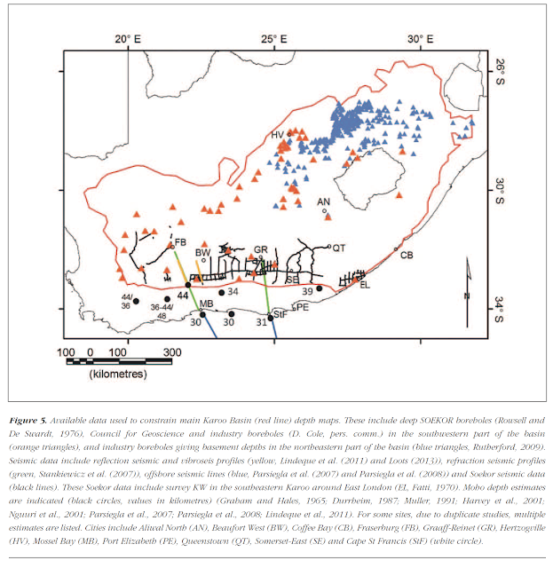
Figure 2 - Existing data in the Karoo summarised by Scheiber et al. (2015).
Data: 1. Deep SOEKOR boreholes (Rowsell and De Swardt, 1976), Council for Geoscience and industry boreholes (D. Cole, pers. comm.) (orange triangles)
2. Industry boreholes giving basement depths (blue triangles, Rutherford, 2009).
3. Reflection seismic and vibroseis profiles (yellow, Lindeque et al. (2011) and Loots (2013)),
4. Refraction seismic profiles (green, Stankiewicz et al. (2007))
5. Offshore seismic lines (blue, Parsiegla et al. (2007) and Parsiegla et al. (2008))
6. Soekor seismic data (black lines; Fatti 1970, 1987)
7. Moho depth estimates are indicated (black circles, values in kilometres) (Graham and Hales, 1965; Durrheim, 1987; Muller, 1991; Harvey et al., 2001; Nguuri et al., 2001; Parsiegla et al., 2007; Parsiegla et al., 2008; Lindeque et al., 2011).
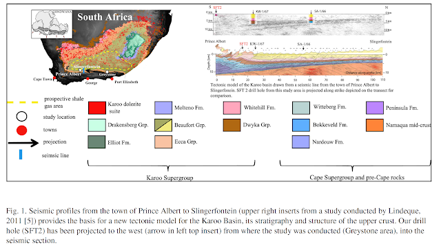
Figure 3 - Borehole SFT2 in the southeastern Karoo (Greystone area) drilled by Aeon (Geel et al. (2013))
Figure 4 - Karin boreholes drilled in the southwestern Karoo (KZF-01) and southeastern Karoo (KWV-01)
Figure 5 - Council for Geoscience study area around Beaufort West


Comments
Post a Comment